


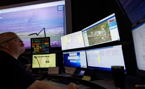
Firemen in the US state of California are using Artificial intelligence to help them monitor, spot and prevent wildfires and disasters.
More than 1,000 strategically positioned cameras are used to feed video into a machine that notifies first responders when to mobilise.
A camera discovered a fire that started at 3 a.m. local time in the remote, scrubby Cleveland National Forest, some 50 miles (80 km) east of San Diego, as an illustration of the possibilities of the ALERTCalifornia AI programme, which was launched last month.
It could have turned into a roaring inferno while people were asleep and the smoke was hidden by darkness, but AI notified a fire captain, who dispatched roughly 60 firemen, including seven engines, two bulldozers, two water tankers, and two hand teams. According to Cal Fire, the fire was put out in 45 minutes.
The platform, which was created by engineers at the University of California San Diego using AI from the Chico, California-based company DigitalPath, depends on 1,038 cameras installed by different public agencies and power utilities across the state, each of which can be rotated 360 degrees at the command of remote operators.
Although it didn’t yet have a thorough report, Cal Fire gave further examples of AI alerting fire captains to a fire before a 911 call was received since the AI programme started on July 10.
The sample size thus far is too tiny, according to Neal Driscoll, a professor of geology and geophysics at UCSD and the project’s primary investigator, to draw any firm conclusions.
The necessity for such equipment has been highlighted by this season’s extremely destructive wildfires in Hawaii, Canada, and the Mediterranean, and Cal Fire hopes that the technology may one day serve as a model for other states and nations throughout the world.
Beyond the range of human eyesight, infrared and other wavelength data are also being collected by aircraft and drones.
The platform can measure atmospheric rivers and snowpack in the winter. According to Driscoll, the UCSD team is also gathering information on burn scars and their effects on erosive processes, sediment transport, water quality, and soil quality.
The data could eventually be used to predict fire behaviour and advance as-yet-unknown AI applications for researching the environment. It is accessible to any private enterprise or academic researcher.


