


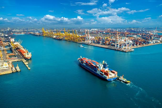


The African Export-Import Bank has donated $350,000 to maximize the use of transportation on Nigeria’s interior waterways.
According to The Sun, the African Export-Import Bank, the Nigerian Export-Import Bank, the Federal Ministry of Transportation, and the Nigerian Navy have joined forces to chart the Lower River Niger to improve water transit in Nigeria.
The Lower River Niger Navigational Charts were unveiled by the Minister of Transportation, Mr. Mu’azu Jaji Sambo, with assistance from Mr. Boss Mustapha, Secretary to the Government of the Federation.
Sambo acknowledged the significance of water transportation, citing the United States of America as an example, where 60% of agricultural produce is moved through inland waterways as the most environmentally friendly mode of transportation with significant economic benefits.
He expressed appreciation for everyone’s efforts and promised to continue forward with the actions that would be needed to allow for the passage of goods on the lower River Niger.
Afreximbank was represented at the event by the Manager of Trade Finance, Anglophone West Africa, Mr. Remigius Nwachukwu. He praised Prof. Benedict Oramah, President and Chairman of the Board of Directors of Afreximbank, for his vision and leadership in realizing the project, which is within the scope of Afreximbank’s mandate to promote, facilitate, and finance intra- and extra-African trade.
The Afreximbank pointed out that the continent’s current infrastructure was built to transport African goods to international markets rather than to promote trade within the continent. To ensure efficient and affordable channels to allow intra-African trade under the African Continental Free Trade Agreement, Afreximbank made the decision to support the development of the maritime sector, particularly inland waterways, in this context.
The release of the nautical charts comes after the completion of a maritime survey and charting project by the Sealink Consortium, the Nigerian Navy, the Nigerian Inland Waterways Authority, and Neximbank, which was funded by an Afreximbank grant. The charts offer details on the river channel’s restricted and navigable portions and act as a starting point for creating a fully developed navigable channel.
The International Centre for Electronic Navigational Charts accepted the charting since it complied with IHO requirements and covered a distance of 456 km from Jamata, Lokoja to Burutu.
Navigational activities can begin with the use of the Charts, which Mariners can obtain from the International Centre for Electronic Navigational Charts in either hard copy or electronic form. Although some additional work, such as dredging and the removal of identified wrecks is still anticipated to be done on the channel.


